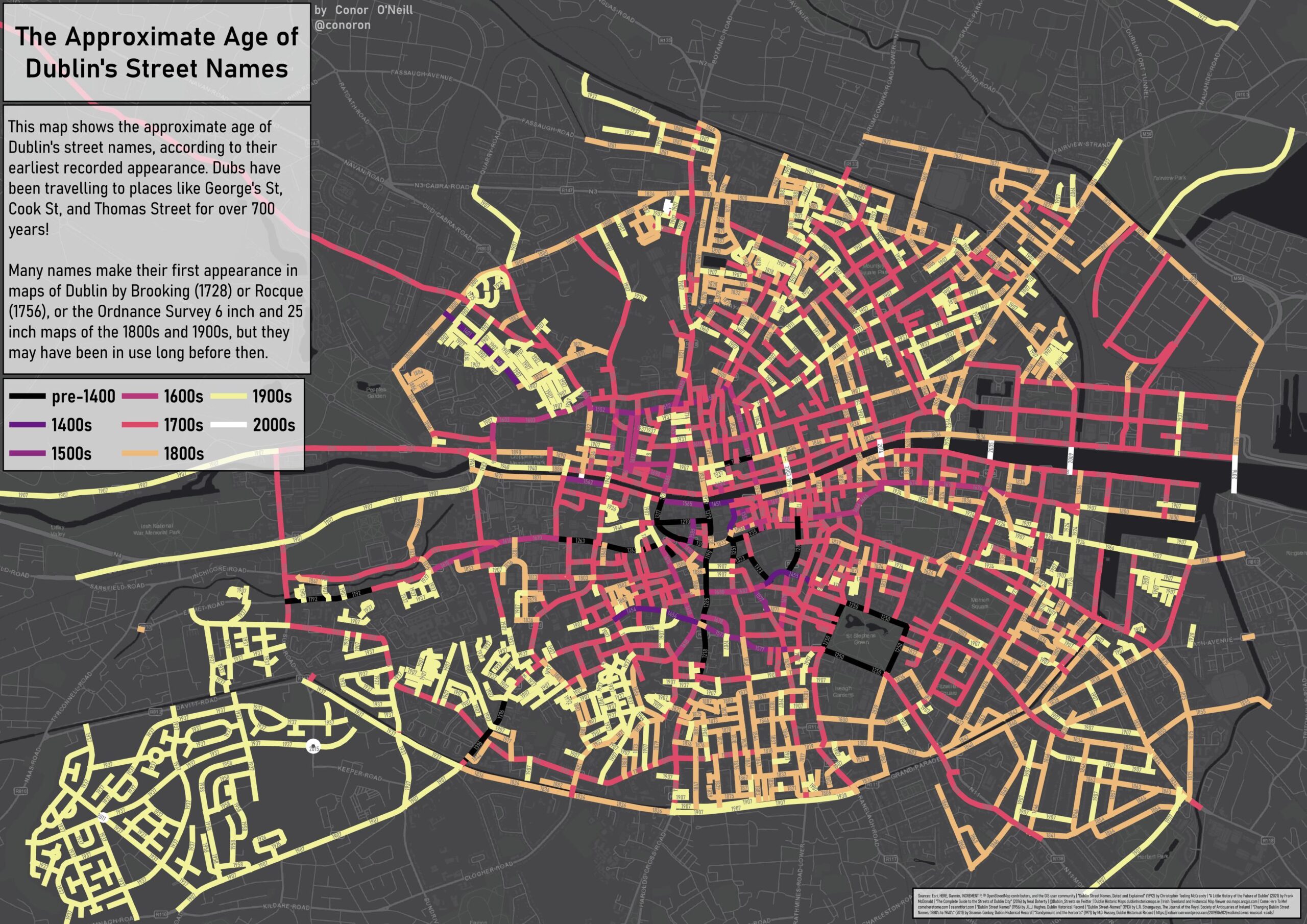
November 2023 – I’ve updated my map of Dublin’s street names, making a few corrections and adding a good few more dates. The dates can be difficult, because I’ve been limiting myself almost entirely to historic maps of Dublin. However, getting into the OSI’s 25 inch (1907-ish) and 6 inch (1836-ish for the first edition and 1937-ish for the last edition) maps has allowed me to add a load more dates. Obviously street names may have been in use a good bit before their first appearance on a map, but it’s at least a handy reference point.
I got interested in where the names for some of Dublin’s streets originate from while reading A Little History of the Future of Dublin by Frank McDonald. In explaining the history of the development of Dublin, he discusses the likes of Luke Gardiner, 1st Viscount Mountjoy, and James FitzGerald, 1st Duke of Leinster. These men, who were Irish landowners, property developers, politicians, and soldiers, among other things, gave their names to places like Gardiner Street, Mountjoy Square, Kildare Street, and Leinster House. I had never thought much about where those names came from, but it sparked an interest.
I got to work on QGIS, manually drawing Dublin’s streets and adding in the information as I found it. While I used McDonald’s book to begin with, I soon found Dublin Street Names, Dated and Explained by C.T. M’Cready on Google Books. The project quickly became (largely) a digitisation or visualisation of this book, which lists the name, origin, and earliest appearance of each of Dublin’s streets, as they were at the time of publication in the late 19th Century. Not only was this a great source for the origins of the names, it also added the age of the names, or at least their earliest known appearance. I think this side of it is just as interesting as where the names came from.
While M’Cready’s book provided the vast majority of info, it only went up to the late 1800s. I used a variety of other sources as well, including @Dublin_Streets on Twitter, The Complete Guide to The Streets of Dublin City by Neal Doherty, and McDonald’s A Little History of the Future of Dublin.
I stuck mainly between the two canals, firstly as I needed to stop somewhere and the canals form a handy border, and secondly because outside the canals sources for the names become much harder to find.
I’ve essentially made three versions of the map.
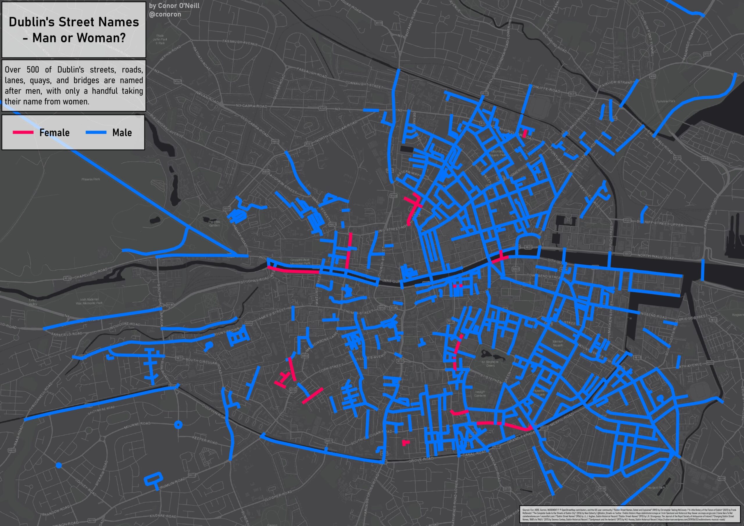
The first shows whether streets are named after men or women (or neither, e.g., College Green, Parliament Row, etc.). This, disappointingly but unsurprisingly, is heavily skewed towards men. Where women do feature, they are typically a Queen (Victoria Quay, Adelaide Street) or known because of their marriage (e.g., Henrietta Street, named after Lady Henrietta Somerset, wife of Charles FitzRoy, 2nd Duke of Grafton).
Mary Street, South Great George’s Street, St Stephen’s Green, Patrick Street and some others are marked as not named after people as they were originally named after churches. This might seem a little strange or pedantic, but I think it follows the same logic that, for example, Kildare Street is named after James Fitzgerald, 20th Earl of Kildare, and not the county.
The second map shows the approximate age of the street names, taken from their earliest recorded appearance (in a map or other document). I think this map pretty much speaks for itself. It’s cool to think of generations of Dublin people referring to street names we still use today. Fun fact: New Street (south) is one of the oldest names still in use in Dublin, first appearing in 1218!
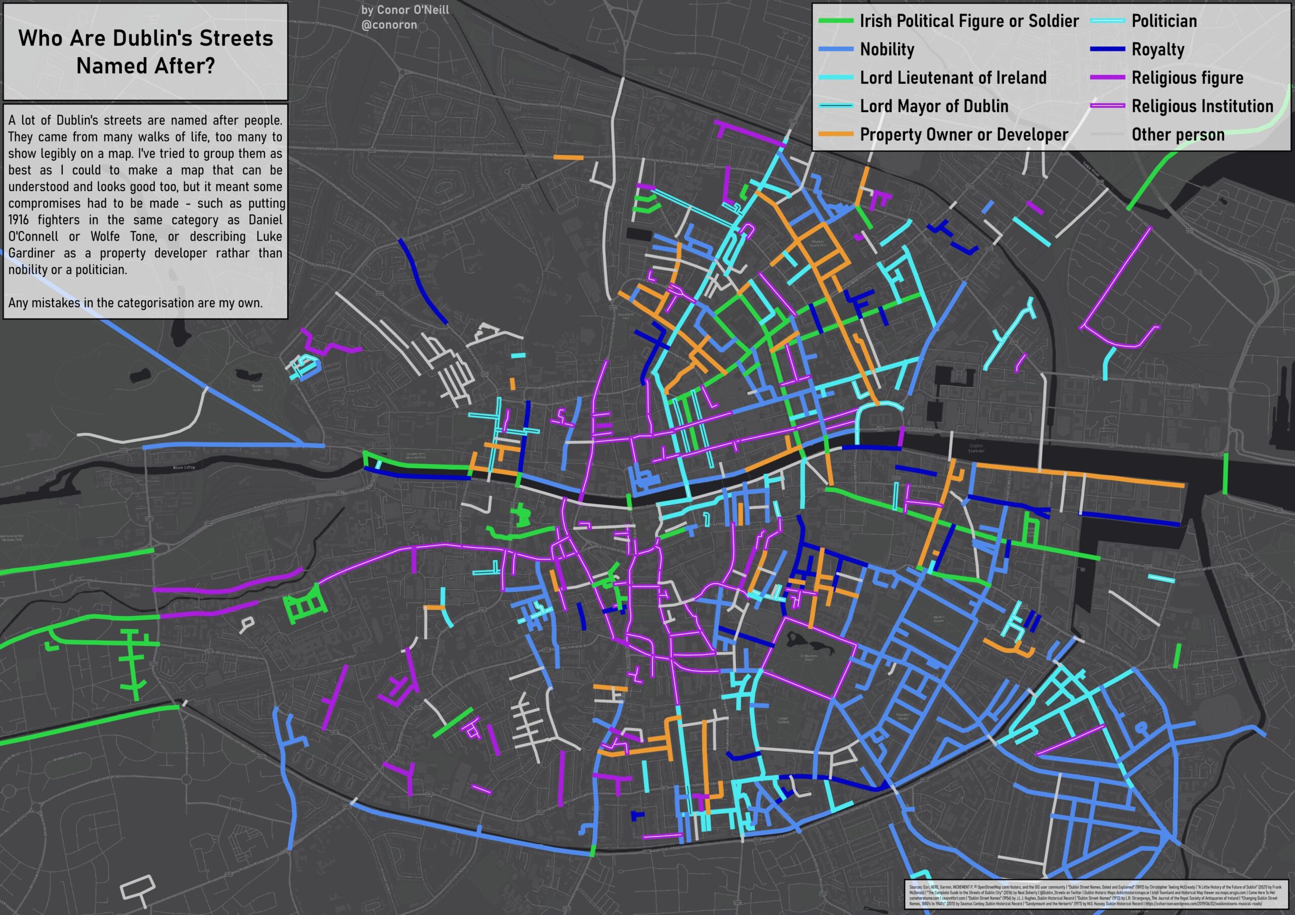
The third map dives into the role or position of people named in Dublin’s streets. This was a difficult one as I had to make some compromises to keep the map legible – I’ve combined Daniel O’Connell, Wolfe Tone, and 1916 participants into “Irish Political Figures”, for instance. I also had to decide which category some people best fit in. Do you describe Luke Gardiner as nobility (he held the titles of Baron and Viscount), a politician (he sat in the Irish House of Commons), or a property developer? Within the context of the map, I decided on the latter, due to his role in development on the northside. Doubtless I’ve gotten things wrong and put some people into the wrong category, but I’ve provided links where possible so you can read up on those who are named.
Click here to view the map. The layer list is in a popup on the top right of the screen, hover over it and turn the layers on or off to view them. Streets can be clicked on to view information on each individual one.
Leave a Reply